Monte Carmo per il sentiero degli ometti
Uphill route, sometimes very challenging.
Our starting point will be the Pian delle Bosse refuge, where an e-bike charging station has recently been installed.
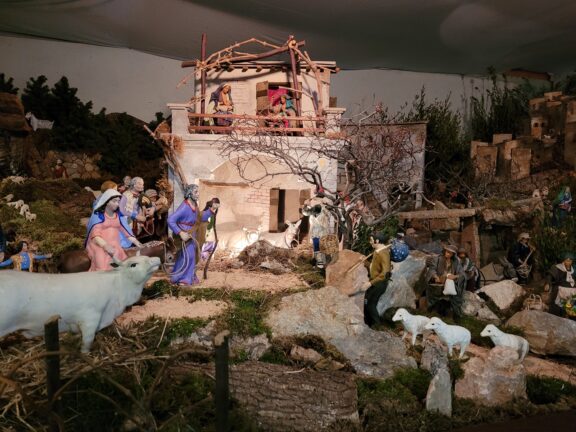
We continue in a south-westerly direction, following the signs for Rocca dell’Aia. At a good pace we soon come to a fork where we must follow the signs for the “degli ometti” path and the “Scoglio del Butto”. Here, at a jutting outcrop, a characteristic crib has been set up and is maintained all year round. The characteristic feature of the path is that it is only marked by cairns, which are frequently used, but this requires constant attention to look for them, especially later on.
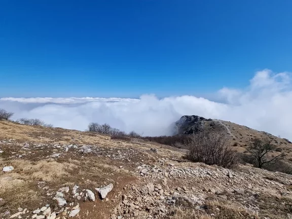
This demanding path traverses the wooded slope with accentuated ups and downs and then, when the thick hazel grove gives way to Mediterranean scrub, it climbs briefly to a rocky knoll: this is where the most interesting and spectacular part of the path begins. In fact, the trail continues halfway up the hillside, among towers, balconies and quartzite gendarmes, cutting across several steep wooded valleys that isolate the various rocky structures. Splendid views, from above, of the Rocca dell’Aia and, in the background, the coast between Loano and Pietra Ligure. A steep stretch of ascent gains about a hundred metres.
Continuing along the path, you pass a daring tower, then climb to a tongue of rubble, overlooked by a smooth pillar: at the end of the rubble you go round a rocky edge equipped with a fixed rope and climb up to a splendid rocky pulpit, from which you can still enjoy a beautiful view of the quartzite Rocca dell’Aia complex.
quartzite complex of Rocca dell’Aia – Scoglio del Butto. From here on, the trail briefly reaches the summit, occasionally losing the signs. A junction with a Terre Alte path takes us to the Amci Del Carmo refuge, just 10 minutes from the summit cross with a breathtaking 360° panorama.
We descend by a different route, much less demanding, returning to the clearing of the refuge we follow the little ball indicating the Pian delle Bosse refuge (1h10min) avoiding the ridge path, which is also demanding on the descent. The path is almost completely marked under the Alta Via dei Monti Liguri, and the signs are often clearly visible. The path called “delle scalette” crosses the whole forest from the north side, in constant shade, cold and damp. When we reach the “Giogo di Giustenice” we follow the cart track for a good quarter of an hour and then take the signposts on the right, in a large bend, which will take us back to our starting point. Along the path, which is very clean, many snowfields are still visible.
Another good half hour of ascent and we will be at the meadow where we started the route. Reservations are recommended at the Pian delle Bosse refuge to refresh yourself with good food after the strenuous climb.
Fonte: Due zaini e un camallo.