Loano, trekking urbano
In this special edition of our project for the enhancement and discovery of the area, we focus on Loano, its historical and cultural aspects, analysing them in order to offer you tourist and gastronomic experiences that are new in the way we propose them.
As good guides, we can only begin with the history of Loano.
Located in the centre of the Riviera Ligure di Ponente, the territory of Loano is an integral and fundamental part of the Riviera delle Palme.
It is no coincidence that the term Riviera is written in capitals; history tells us that towards the end of the 1800s, the greatest Anglo-Saxon travellers used it to indicate the strip of coastline that led from Hyères, on the Côte d’Azur, to Lerici, in the La Spezia area.
It is thus transformed into a proper name which, in order to be geographically distinct, must be “adjectivalised” as “Ligure di Ponente” – to distinguish it from the not so distant “Riviera Romagnola” which, in theory, should not enjoy such an appellation.
Loano lies at the mouth of the Nimbalto torrent, between the municipalities of Pietra Ligure and Borghetto Santo Spirito.
Its strategic position, protected by an arc of mountains, the highest of which is Mount Carmo (1389 m), means that Loano enjoys a particularly favourable climate all year round. It is no coincidence that the experiences we are going to describe, trekking and all the related sporting activities can be enjoyed 365 days a year.
In fact, there are only a few days in the year when adverse weather conditions make any kind of practice impossible.
In many tourist references, events and even mentions of national importance, next to the name of Loano we often find the appellation “isola del Ponente” or “pearl of the Ponente”.
The first historical references to the Loano we know today take us back as far as ancient Rome. As we have learned in our small and modest project, the first step in discovering the roots of a place is to analyse its name and focus on its meaning. After carrying out some research and consulting various texts, we find an initial reference dating back to the 3rd century AD, which identifies this part of the territory as Lollianum, i.e. land belonging to the Gens Lollia, a family dedicated to military life in the ancient Roman Empire. On the time scale we are placed between 235 and 284, under the Severan dynasty and during Diocletian’s rise to power.
As often happens in the course of history, names are mispronounced, in this case Lollianum was changed to Loejan and later Loean, very similar to the current dialect name Leua.
Another more recent theory, reported on the institutional website of the municipality, attributes the origin of the name Loano to the assonance with the name Lodanum and to the locality Lodo, located near the Poggio di San Damiano (on the nearest hill), the first medieval settlement in the area called Lodanum super podium.
The municipal territory consists of two main urban agglomerations: Loano and the small and lively Verzi.
In order to orient ourselves in the description of the town of Loano, which as a whole is made up of many districts and hamlets, here is a map that best represents the local subdivision. How popular names have remained intact over the centuries can be seen in the subdivision of the territory itself, with each strip of land having a precise name that identifies it. The distinction of areas, the names of neighbourhoods and localities is often a matter of principle for the “vecchi de Leua” who still use these names to seal their attachment to the Loano of old.
The best-known and most famous districts are often mentioned, together with the name of the street that runs through them, on the roadside plaques.
The less well-known ones, on the other hand, are sometimes mentioned verbally but are less and less handed down to current generations. A fixed point for the localisation shown in the above illustrated table (provided by Andrea Calcagno of the Castigamatti studio) refers to an extract from the Gazzetta di Loano dated 1939, “I toponimi del Comune di Loano” written by Dr Enrico Cavalli (1891 -1976). Our urban itinerary starts at the edge of the town, at the Residence Colibrì Family & Bike (www.residencecolibri.it) run by Luca and his family (since 1992!) A family-run accommodation facility located right on the seafront, open all year round. We are located a few steps from Pietra Ligure where the ancient border was marked by the Rio Ciappe (or Rio da Fin) from which the locality Chiappe takes its name (4).
The etymology ‘Chiappe’ probably derives from the dialect word ‘ciappa’, meaning stone, a large, smooth, flat stone. The smaller stones were used for the dry-stone walls that bordered the numerous vegetable gardens that stood here and which are now less visible.
A pleasant walk along the seafront promenade that runs the length of Marina di Loano, the nerve centre of maritime tourism in Liguria, brings us closer to the centre of the village.
On our way we immediately come across a large port that can accommodate almost 1,000 boats, allowing all maintenance and repair operations to be carried out directly inside the Marina itself, in an easily accessible basin protected by an imposing breakwater that makes it safe in all seasons and in all weather conditions. To complete the tourist offer there is a bathing establishment of about 16,000 square metres and a trendy restaurant/pizzeria. Just beyond this area, one of the first attractions of the territory as you follow our urban trek is the area dedicated to the mooring of fishing boats and the subsequent fish market where, every morning, you can watch the fishermen return and offer their fresh, “0 km” fish products, a local boast without equal in the area.
In addition to their main activity, some fishermen offer fishing tourism in the summer and winter seasons for the more daring.
This is a real experience on board a fishing boat to experience at first hand a part of a typical Ligurian fisherman’s day.
typical day of a Ligurian fisherman. We meet a sea “veteran”: Peppo. He is a professional fisherman who has been offering this tried and tested service on board his “Paolo il Grande” for years.
What you can experience together with Peppo are two distinct moments of the day. In the afternoon, the nets are “lowered” into the sea, i.e. together with the fisherman, the nets or lines are lowered in an outing that lasts about two hours. Alternatively, you can opt for the “hard rise” at dawn, which involves recovering the equipment (nets and lines) lowered in the evening or the previous afternoon, in which case the outing takes about three hours, with the actual fishing.
For info and reservations: Peppo 347/8323922
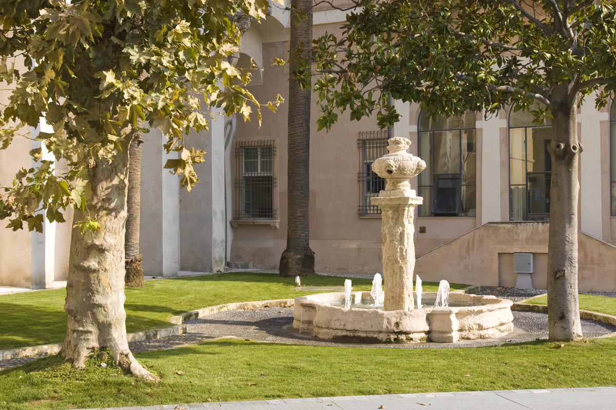
We continue along the promenade, passing a three-metre-high sculpture in Aurisina stone, representing the mythological god of the sea “Neptune”. This work of art is a fountain belonging to the “circuit of the author’s fountains”, a sort of permanent open-air art gallery, designed to bring art into daily life and to provide tourists with points of reference for a tour of discovery of the town. There are six in total, plus the 16th-century “Fontana Giovanna” near the town hall, which is part of Loano’s historical and cultural heritage.
A nice way to admire them all while doing some healthy sport, whether walking or running, is to follow the route designed by the ASD Maremontana di Loano (which can also be viewed on their smartphone app); it is an urban ring of about 4 km designed to be walked by the whole family.
We continue beyond “il Nettuno” and head for another key point in the maritime and sporting life of the Marina di Loano: Corrado Ambrosi’s Diving Center, in operation since the early 1990s.
This is a real feather in the cap, attracting many sportsmen and women every year to explore the rich seabed off our coast, as well as newcomers wishing to take their licence and experts wishing to hone their skills in this discipline.
Three wrecks off Loano are of great interest:
1 – the Tiphlis. This is an English ship/hospital on the seabed in front of the Santa Corona Hospital in Pietra Ligure, dating back to the 1940s and in good condition. With the right precautions, it is possible to go inside, where a large cavern creates an evocative play of light and shadow. Large lobsters and, during the winter, anglerfish are frequently encountered.
2 – The San Guglielmo. This was a luxurious first-class passenger ship, converted into a troop transport during the First World War, and was sunk by the Germans. From an underwater point of view, it is very interesting because you can see groupers, moray eels, octopuses, scorpion fish and nudibranchs.
3 – The Sassari City. It lies on a sandy bottom at a depth of about 28 metres in front of the coast of Borghetto Santo Spirito. Following numerous interventions to recover valuable materials, it has lost most of its upper structures. Inside, among the remaining metal sheets, you can find the burrows of conger eels, bream, octopus, and in the stern there is a statue of a Madonnina, which since 2000 has been “watching over and blessing” all divers who dive in the wreck.
More information on www.marinadiving.net To reveal some historical facts about the area we are visiting, called Portiglioli (6), we need to take a step back into the past.
The name comes from the dialect Porixoè, meaning small port.
If we look closely, near the chapel dedicated to Our Lady of Loreto, venerated by sailors (which we recommend you visit as it is the oldest existing medieval building on the coast of Loano, dating back to between 775 and 1171) there is a small rivulet, the Berbena stream, once certainly with a greater water flow than now.
According to rural tradition, it was the custom of the old Ligurians to exploit these channels to create small settlements where they could moor their goiters and make them easily accessible for fishing trips, thus creating portixoè, or small harbours. 1960s) to the vicinity of a Roman bridge dedicated to Saint Sebastian, on which a niche contains a votive statue of him.
The bridge of San Sebastiano, symbol of the county of the Doria princes and of Loano, is also called “Du Niciu” (bridge of the niche). It was built by the family that ruled over the Loano fiefdom in 1691 to allow the Nimbalto stream to flow through the back of Palazzo Doria, joining Borgo di Dentro to Borgo Castello.
After crossing the bridge, there are two possibilities: to go along viale Libia passing in front of the Minigolf dei Tigli or to cross Campo Cadorna right next to the walls, still visible today, which mark the beginning of the historical centre.
What characterises the Borgo di Dentro (1) is that it is still possible to see its boundaries, which date back to 1309. Wanted by Raffo Doria, son of Oberto and Lord of Loano, they delimit the expansion of the territory that from Poggio di San Damiano extended towards the coast. In a short time, the people of Loano, protected from enemy raids and “pirates” by the mighty walls, began (in addition to cultivating orchards and vegetable gardens) to found new urban centres and commercial and manufacturing activities.
We cross one of the four ancient (circa 1930s) access roads to the city to find ourselves in the San Josemaria Escrivà Gardens, located right in front of the summer arena ‘Il Giardino del Principe’.
As can be seen from the map (fig. above) dated 1808 from the local historical archive, this area was one with the nearby Palazzo Doria, now the Town Hall. The palace, dating from 1578, was the residence of Giovanni Andrea Doria and his wife Zenobia, direct descendants of the Marquis Del Carretto family. The building was constructed according to the criteria of a ‘palace/fortress’. To the west a pentagonal tower with an irregular base was erected, which follows almost faithfully the perimeter of the walls, and to the east the “Loggetta” was built, which still today looks out over the Ponte San Sebastiano.
Today, on the second floor of the Palazzo Comunale (Town Hall), we can find a large mosaic, discovered in some excavations in the area, which testifies to the strong Roman presence in Loano. This room is used throughout the year as a venue for art exhibitions, photography shows and much more.
At present, the Palazzo Doria, the Pentagonal Tower and the Giovanna Fountain are all located in Piazza Italia, which was recently built.
To the left of the Palazzo, to complete the prestigious buildings that make the area particularly important from a historical and cultural point of view, we find the basilica dedicated to St John the Baptist and the Oratory of the Cappe Turchine. The first was built between 1633 and 1638 and consecrated in 1662.
It is an impressive religious building, decagonal in shape and occupying an area of 480 square metres with a diameter of 75 metres. The church boasts a Baroque interior accessed through a portal where a large stucco bas-relief depicts the Presentation at the Holy Temple. On the majestic dome (the basilica is also known as the Cupolone) stands a gilded statue of St John the Baptist, the patron saint of Loano, to protect the town.
The Oratory next door (called “dei turchini”), belongs to the confraternity N.S. Del Rosario founded in 1661. It houses the majestic statue of the Visitation and numerous wooden crucifixes which are carried in procession every year on the feast day of 2 July for the ceremony of bowing to the sea.
A diversion on our route is obligatory to mention another religious building that in the early Middle Ages became the parish of the newly founded “Burgo in Ripa Maris”.
The current building probably stands on the site of the first Christian church in Loano, therefore prior to 775.
It is currently the seat of the Confraternita dei Bianchi (Brotherhood of the Whites) and it also preserves grandiose crucifixes, torches and sticks used in the traditional processions in the Name of Mary and the Madonna delle Grazie. From Piazza Italia, we take a small, semi-hidden tour that begins with a narrow street winding behind the cathedral.
Via Alla Chiesa remains today a beautiful example of local creuza, even if, in Loanese, it is wrong to call it such. In the western part of Genoa, where we are, the correct dialect word for them is muagie (walls), almost identical to creuze.
Made famous by the popular song “Creuza De Ma” by the Genoese artist De Andrè, these are the ancient Ligurian walls that flank land and gardens, usually to mark their boundaries. Just over a couple of metres high, they were built using local stones of different sizes, fitted together without any glue (in some cases mortar was used).
The creators of these true works of rural art were none other than the farmers themselves, who reinvented themselves as masons (massacan in dialect). There is a local saying: “müa vegie mettan a pansa”, which means “old walls make a belly”, i.e. they become deformed; this happens because the soil and the rains change the shape of the terraces over time. It is not uncommon for walls that have not been maintained by local farmers to collapse after heavy rain, opening up chasms in the walls. This is not the case with Via Alla Chiesa, which has been made safe over time. It is very evocative to walk the whole street, especially because, once you are almost at the end, you will find the ancient wash-houses of Loano, used by the women of the time, before the introduction of running water into the houses, to do their washing. But these places were also meeting places where people went to gather and socialise.
We really like this passage from the Bibliotheca Historica by Diodorus Siculus, a historian who lived between about 90 and 27 BC, who describes the Ligurian people in this way: “They inhabit a stony and barren land and live a strenuous and unhappy life because of the efforts and harassment they endure in their work. And since the land is covered with trees, some of them, for the whole day, cut down the trees, equipped with sharp and heavy axes, others, having been given the task of working the land, do nothing but extract stones … Because of the continuous physical work and the scarcity of food, they keep their bodies strong and vigorous. In these labours they have women to help them, who are used to working in the same way as men. As a result, living in the snow-covered mountains and being accustomed to cope with incredible differences in height, they are strong and muscular in body… They spend the night in the fields, rarely in a simple farmhouse or hut, more often in cavities in the rock or in natural caves… Generally, the women of these places are as strong as the men and the men as wild beasts… They are brave and noble not only in war, but also in those conditions of life which are not without danger.
Those of us who had the good fortune to know our grandparents, and even more so our great-grandparents, can relate faithfully to Diodorus Siculus’ description. At the beginning of the last century, life was still difficult for the Ligurians, but they always stood out for their pride.
Leaving Via Alla Chiesa, we enter the beating heart of rustic Loano, where the scent of freshly baked bread wafts through the tangle of alleyways that we describe below.
This concatenation of little streets is called “I caruggetti orbi”, consisting of a dense network of small squares and alleys, mostly blind: hence the adjective “orbi”.
According to another theory, however, being ‘orbi’ is due to the fact that they ‘never see the light of the sun’ because of the short distance between the buildings. Hidden away in this labyrinth are workshops that carry on arts and crafts where the “handmade” is guaranteed by the presence of the craftsman himself.
We will reveal some of them to you later!
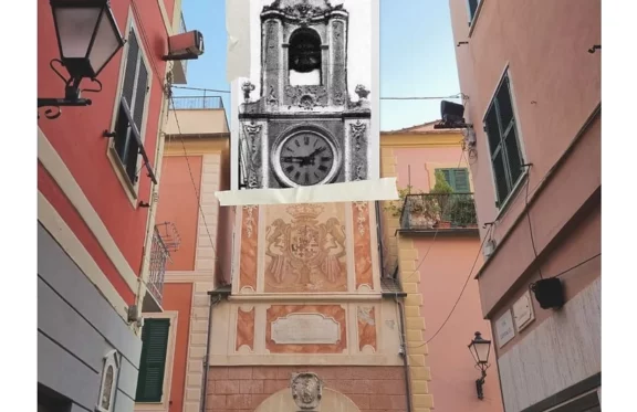
Still on the subject of the ancient city walls, in a side street that connects the old town centre to the seafront, you can see Porta Passorino, one of the four gates that opened in the city walls and that closed the strada di Mezzo, currently Via Cavour, to the west. The identifying monument of Loano known as “L’Orologio”, together with the “Cupolone”, the Pentagonal Tower, Palazzo Doria and the convent of Monte Carmelo, form the skyline that best encapsulates the essence of this town. Porta Passorino, however, was not as we see it today before the 18th century; in 1774, a clock and a turret decorated with the Savoy coat of arms were erected above it.
A detail that can be noticed on the clock face of the tower is the indication of the number 4 written “IIII” (1+1+1) and not according to the usual use “IV” (5-1).
This is not an error but a well-considered choice, which can be summed up as follows:
– Historical: the historical reason relates to the Roman numbering system, which used only the rods, preferring an additive-only system to the additive-subtractive one, introduced later in the Middle Ages.
– Religious: the Romans could not use the form “IV” to represent the number four because it coincided with the initials of the Latin name of the god Jupiter (Ivipeter).
– Social: with the introduction of sundials, the representation of four in additive form made reading the time much easier for people without education.
– Economical: the preference for the IIII form made it possible to save money when making the components for the dial. This optimisation minimised the waste of materials and resources.
After passing through the Porta dell’Orologio we end the tour of Borgo di Dentro and enter the “newer” part of the “old” Loano, Borgo di Fuori (2) and the Orti area (2a).
The main “U caruggiu” is Via Garibaldi, which runs straight up to the junction with Via Cesarea and the Vallino archivolt, known as “Passo Du Gambin”.
Via Garibaldi is what is vulgarly referred to as a ‘budello’ (gut) by passers-by, but claimed loudly in ‘Caruggiu’ with plaques engraved on Finale stone placed at the edge of the street itself.
It is here that the shopping area comes to life most, crowded to the hilt in summer and calm and peaceful on cold winter mornings where the faces you meet are mostly family members or friends.
From the above-mentioned crossroads, the toponym changes to Via Ghilini until it reaches Piazza Massena, then the end of the so-called historic centre.
Above this itinerary, a parallel road, Corso Europa, stretches back to Via Stella.
We choose to turn left, to enjoy what attracts tourists and holidaymakers the most, the seafront.
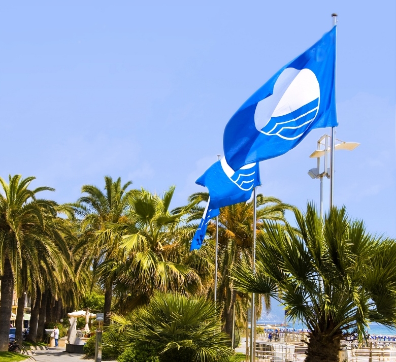
We have deliberately waited until now to talk about it because our intention is to let you know what distinguishes us 365 days a year, and not just in the summer months. The first thing that catches your eye as you leave the narrow confines of the houses is the presence of several flagpoles bearing a prestigious award.
A symbol of the quality of the water, environmental services and hospitality offered by the town of Loano, the Blue Flag is an award for the best beaches in Europe, awarded for 12 consecutive years in 2021.
The parameters taken into account by the Blue Flag are the quality of bathing water, waste water purification, environmental certification, waste management, beach accessibility, environmental education and communication, and sustainability initiatives.
A peculiarity that distinguishes us from other tourist destinations is that in Loano, for the last 9 years, two flags have been waved at the same time: one for the above reasons and the other, awarded to Marina di Loano, certifies the tourist port as a company that carries out its work in full respect of the management of all environmental issues.
The walk, now oriented towards the east, is our turning point and continues sun-kissed alongside all the bathing establishments that animate the area in the summer season.
In a short time we are in front of the artist’s fountain, “Conversation at the Fountain”, designed by the author to invite passers-by to sit on the edge of the pool and socialise, then another easily attracts our attention: “On top of the world” by Ugo Nespolo, a work in lacquered bronze; it consists of a sphere from which streams of water flow, surmounted by the playful figure of a child.
We pass the Orto Maccagli cultural space, where there is an interesting panel dedicated to the outdoors and the territory, with itineraries and useful information for discovering the immediate hinterland.
At this point, if we head north-east, we can see one of the most beautiful and prestigious houses built at the beginning of the 18th century, Casa Maccagli; it is impossible not to distinguish it because of its majesty and its classic candy pink colour, typical of Ligurian buildings of the past. Behind us, a small, centuries-old building stands alone, built at the end of the 19th century as the “Maritime Health Station”. It was the headquarters of the customs and sanitary control of maritime traffic, and later became the headquarters of the Guardia di Finanza beach delegation. It is currently the headquarters of the Associazione Lavoratori del mare (Association of Sea Workers), a small museum that houses relics and memories of Loano’s life at sea.
Ours is a very widespread urban trek that is slowly coming to an end, but still has a couple of pearls in store.
On our website (www.duezainieuncamallo.com) you can download the free .GPX track of the route, which will help you to follow it in the order we have described it. It is our custom to make what we experience first hand available to everyone as if we were walking the route together.
We remain on the promenade and proceed in a straight line towards the “old” pier, characterised by a building placed at the end towards the sea, in the shape of the prow of a blue ship.
In the immediate vicinity, in addition to the gardens named after the Fallen of Nassyria and the municipal playground, stands the imposing Palazzo Kursaal, home to numerous local associations, the municipal library and the Museo Del Mare.
We will focus on the latter!For many years now, the Lodanum Association has had a small museum-type structure in which it houses and exhibits objects and documentation on the Loano and western Savona maritime history. In particular, it has collected numerous historical and cultural materials such as books, documents, photographs and models that bear witness to the area’s seafaring past. This heritage is currently on display in the central hall of Palazzo Kursaal.
It is a historical-documentary retrospective of Loano’s seafaring and tourist past through images, drawings, documents and objects. The photographs represent a historical and cultural trail that starts in the second half of the 19th century and reaches the first half of the 20th century. The exhibition offers images from the early twentieth century depicting fishing, shipbuilding and the beginnings of seaside activities. Photography then helps to reconstruct the changes in the economy, landscape, environment and society throughout the 20th century up to the 1950s. A wealth of documentation bears witness to mercantile development, the boost in maritime traffic and shipbuilding in the 19th century. The photographic exhibition features images of Loano divers who took part in internationally renowned missions, such as the salvage of the Scirè off the coast of Haifa.
The objects on display include numerous items made by Loano sailors while embarking on merchant ships, as well as shipyard equipment, sailing gear and a rich collection of telecommunications materials.
A tour that deserves time and attention, a good hour to be fully experienced, otherwise a touch and go just to get into the maritime atmosphere. Guided tours can be booked by calling 019/673366.
Leaving the museum, we cross the street and pass under the archivolt of Via Giuseppe Riello which, intersecting with Via Boragine and Via Cavour, guides us towards Via Doria to take us back to Piazza del Comune.
Here we have an appointment with the mayor of Loano, Luca Lettieri, who takes us on a tour of the important historical archive preserved in Palazzo Doria.
Located in four rooms, it contains papers dating from the end of the 16th century to 1970. The Mayor tells us that, thanks to a contribution from the Archival Superintendence of Liguria, the historical archive has been inventoried and reordered by Dr. Iolanda Bovani.
The inventory makes it possible to trace the exact location of the deed in the archive premises, making its use more functional.
It is a real well of precious information for the community, where it is possible to observe even the oldest deeds dating from 1594 to 1759. The first room contains the records of the Civil Hospital, the Monastery of St. Augustine, the parish of St. John the Baptist and the Orphanage.
Among the most precious volumes are offered for viewing:
the will of Pietro Richeri: the oldest from 1605
the will of Giuseppe Repetto dated 1864.
In the adjoining rooms there are registers of protocol, public works, administrative elections, acts of the conciliation office, accounting acts of the institution, cadastral registers from the Napoleonic era, registers of rural property and buildings, acts relating to changes in land ownership and buildings, roles for the tax on land and buildings, requests for cadastral changes, notes of property transfers and a valuable and important Napoleonic edict whereby Decree no. 62 of 1807 established the cadastre of the Kingdom of Italy.
It is in this volume that we have recovered the copy of the map of the centre of Loano dated 1808 (Napoleonic cadastre) shown a few pages earlier.
All in all, this is a valuable resource of historical/cultural value without equal throughout the province.
At the end of this visit and after saying goodbye to the mayor, we start walking again, passing in front of the Giovanna Fountain (dating from the sixteenth century) and the Pentagonal Tower, which we leave behind us to cross the level crossing and the Via Aurelia.
We then take Via Sant’Agostino and head for the hamlet of Prati e Braia (14), whose name has been almost completely forgotten locally.
In this place there is another building, so dear to the people of Loano, dating back to the period of the Dorias: the Church of Santa Maria della Misericordia, commonly called Church of Santa Rita and Sant’Agostino.
It was founded in 1582 by Zenobia Del Carretto, whom we mentioned earlier.
It is the first imposing religious complex built in Loano by the Doria, on the foundations of a chapel and a small earlier convent of the Minims, also built by the Doria.
The convent was not actually finished until 1604. The church has a very simple façade, a wider central entrance and two side entrances carved in Verezzi stone. A plaque on the portal commemorates the builders, Princess Del Carretto and Prince Giovanni Andrea Doria I. The interior is tripartite with two rows of columns in Verezzi stone and is a precious 16th-century art gallery that has recently been restored. To the right of the church, the convent was built around the cloister. In the past, a tree-lined avenue ran from the convent to the rear entrance of Palazzo Doria, of which only a few faded historical photographs remain today (G.B. Cepollina collection).
The route of the Dorias’ devotion is completed by the Convent of Mount Carmel, which represents one of the most interesting works of late Ligurian Mannerism.
To reach the monastery of the Discalced Carmelites, we have to cross one of the areas of Loano still used as agricultural fields: Via dei Fei crosses the village of the same name (17).
We are to the east of the Nimbalto river, a primary source of water for irrigating the fields, where the etymology “Dei Fei” derives from figaretum, or fig-growing place. We reach the imposing ecclesiastical complex overlooking the Costino hill (25) crossing a perfect example of well-preserved Roman architecture, the bridge connecting the convent to the “Burgu”, or Borgo Castello (3).
This is a very old settlement, part of the old medieval agglomeration, where all the activities necessary for the sustenance of the feud were located. Inside some of the houses and cellars there are remains of gumbi (oil mills), kilns, stables and drinking troughs.
Borgo Castello was provided with running water thanks to the Beo del Principe, an innovative system whose remains can still be seen today.
Passing through the village square, we take the first alleyway on the right and enter a street at the foot of a not-too-difficult slope.
Mirroring the cobbled ramp on the opposite side, the viaduct is the main route to Monte Carmelo, which we will tell you about later in a dedicated article. At the square in front of Monte Carmelo we can see and admire (only from the outside, alas) the prestigious Castello Doria, currently owned by the Percassi family.
Luca had the pleasure and the good fortune, because we are talking about a fortuitous event, to have been able to visit it during the FAI day back in 2016.
The castle stands in a dominant position with a splendid view of the sea. It dates back to the early 1200s when it was built as a fortified enclosure for military use, and then, with the first Dorias, it became the residence of the feudal lords.
It was only in the 16th-17th centuries, following major renovations commissioned by the lords of the time, that it took its present form as a Renaissance palace. Sold to the Fieschi family in 1505 and returned to Andrea Doria by Emperor Charles V in 1547, it was managed by the illustrious family until 1736, when it became part of the Kingdom of Sardinia. The property houses 11 bedrooms, a billiard room, the ballroom, a family chapel, ancient prisons and a large, independent service area, as well as a private park of about 1.7 hectares with a swimming pool and outbuildings, a heliport and a finely restored hamlet.
There is no need to tell you about the splendid view of the sea, because we can’t go up to the terrace to admire it! At the foot of Mount Carmel and to the side of Borgo Castello, a narrow street, Via Padre Enrico, is the epilogue to our urban itinerary designed to help you discover Loano.
The last long series of dry-stone walls flanking uncultivated fields and some of the monks’ properties take us to the Vignasse area (5), where it is clear from the name that their prerogative is vineyards.
Fonte: Due zaini e un camallo.