A network of paths weaving between sea and mountains, forests and scenic ridges. A few steps are enough to moving from the blue of the coast to the green of the olive trees, from ancient hamlets to the silences of the woods, in a continuous interplay of views and perspectives.
Trekking & Hiking
The paths around Loano
Whether it is a rejuvenating walk for the whole family or a more challenging hike for experienced hikers, the paths around Loano offer experiences capable of excitement in every season, guiding walkers to discover landscapes to remember and a living, welcoming nature.
Mount Carmo
Mount Carmo dominates the coast from above, offering spectacular scenery to hikers. The southeast ridge, rocky and linear, is traversed by a steep but very scenic trail, which gives unforgettable views of the sea and surrounding hills.
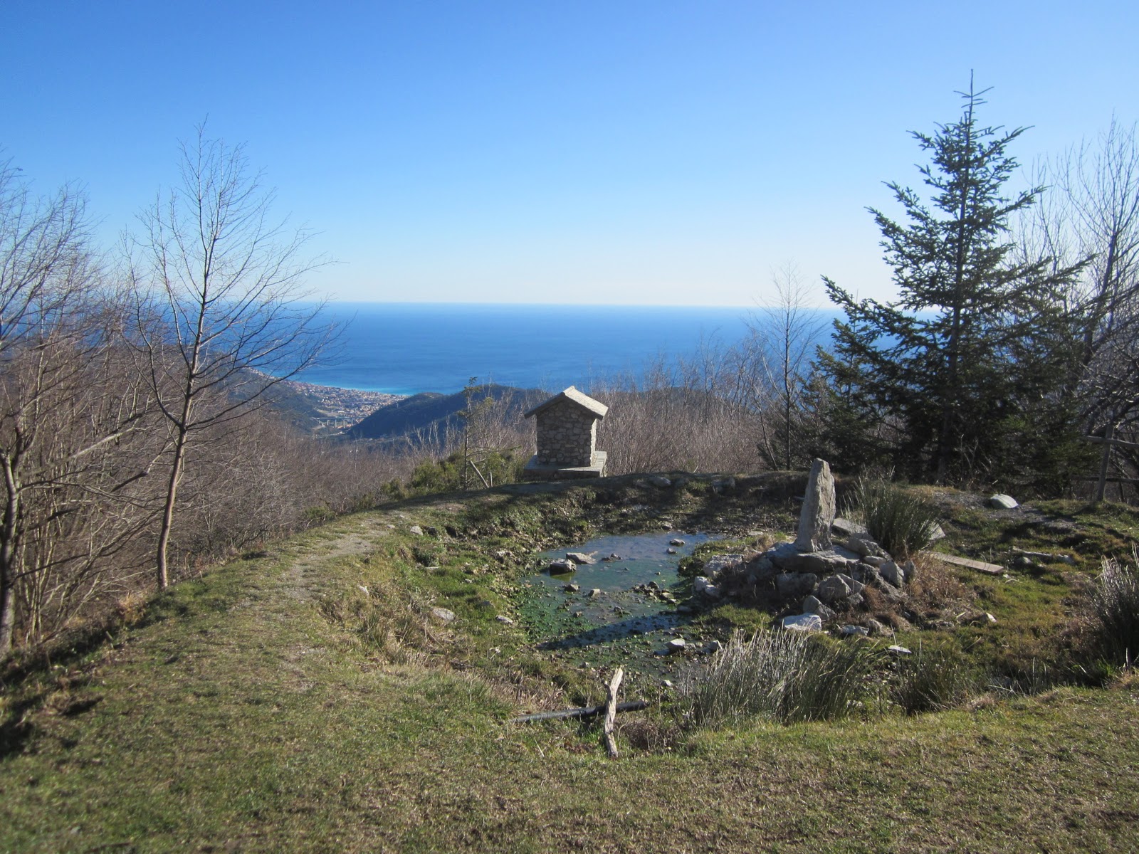
Trail to Pian delle Bosse
A 7.5 km trail that reaches a maximum altitude of 841 meters, suitable for young and old. The refuge is located in an ideal setting for nature and botanical lovers.
From Loano you drive to the hamlet of Verzi and, following the signs to the refuge, continue to Castagnabanca, where a large square serves as a parking lot. From here starts the path that leads to Martinetto Bridge and, after a short climb, to the refuge: about a 20-minute walk, which becomes 40 if accompanied by children. Once there, booking in advance, it is possible to enjoy typical Ligurian dishes in a simple and welcoming atmosphere.
Dry stone wall trail
A 7.5-kilometer route, with a maximum altitude of 139 meters, ideal to be walked by the whole family. Accompanying along the way are the typical dry stone walls of Liguria, a symbol of the peasant civilization: made by hand with rough and irregular stones, they were used to support the terracing cultivated with olive trees and vineyards. This ancient construction technique, considered a true art, has been recognized by UNESCO as an intangible cultural heritage of humanity.
Starting from Corso Roma, one enters Via Stella, continuing to Via Aurelia and continuing straight upstream along Via Matteotti. One reaches the first of the ancient hamlets, the Mazzocchi. Continuing along the route you will also come across Borgo Castello, dominated by the imposing Doria Castle, now a private residence and visitable, on some occasions, during FAI days.
Among thyme gorse and rosemary
A 14.5-kilometer route, simple but full of natural suggestions, ideal for breathing deeply and being enveloped by the scents of thyme and rosemary, typical of the Mediterranean maquis.
From the locality of Morteo one takes a wide ascent that leads inside the forest, among cysts and gorse, to the hamlet Chiesa di Verzi. Once past the small hamlet, the landscape changes and the terrain becomes more stony, with the presence of maritime pines. Continuing along the ridge dirt road in the direction of Ranzi, the vegetation is enriched with chestnut and oak trees until reaching the hamlet of Santa Liberata, where a fountain with drinking water offers a pleasant stop. The return trip is along the CAI path leading to the small church of San Damiano, with numerous viewpoints along the way offering views of the coast and the Ligurian hinterland.
St. Pietrino of Verzi
The 11-kilometer itinerary starts in the hamlet of Verzi and, through countryside and olive groves, leads first to the Morteo area and then to Boissano. From the center of the village, take an old mule track that runs alongside an animal pen, where it is not uncommon to encounter cows and baby goats.
The trail, initially shaded, gradually opens into the Mediterranean scrub until it reaches the meadows of the small church of San Pietrino, an ideal destination for a spring break. After a clearing, the trail continues with a gentle alternation of ascents and descents until it reaches the small country church of Santa Libera: from its churchyard, the view sweeps from the hills to the sea line, offering one of the most characteristic panoramas of the Loano area.
Mount Piccaro
The short but technical hike to Monte Piccaro begins in Borghetto, along the Aurelia in the direction of Ceriale, where a recent flight of steps marks the entrance to the trail. The rather steep trail leads through Mediterranean scrub and olive groves, amid the scents of thyme, broom, maritime pines and strawberry trees.
The half-steep ascent leads to the saddle below the summit, from which in a few steps you reach an impressive viewpoint with a small chapel and Madonnina. From here the view embraces the entire coastline, from Cape Noli to Gallinara Island, as well as the plains of Borghetto and Albenga. The summit of Piccaro lies a little higher up.
Rock of the Hague
The loop trail, suitable for trained hikers, starts and ends at the Castagnabanca parking lot, reached from the hamlet of Verzi. Surrounded by greenery amidst shrubs of arboreal heather, it leads in a few minutes to an unexpected surprise: the Rocca dell'Aia, also known as Rocca dell'Avio, an imposing quartzitic tower that seems inaccessible from afar but which, at its base, reveals numerous climbing routes with imaginative names such as “of the chimneys,” “of the flying goats,” or “of the guardian of the fauns.”.
On the return route, beautiful viewpoints open up, allowing you to admire and photograph the city of Loano from above, giving you an unforgettable memory of the walk.
Borgo Castello and the Holy Staircase
This simple loop itinerary starts from the square of Monte Carmelo, an ideal place for a short stop to admire the cloister behind the nave. Crossing the bridge connecting the church to the Castello hamlet, you enter a small historic core dominated by the imposing Renaissance castle of the Doria family.
We then enter the hamlet and, skirting the walls of the castle estate, continue uphill until we meet the Scala Santa, an evocative and steep path that leads to the summit of Mount Ciazze Secche. The climb is steep and slippery in places, but each stop offers spectacular views of the Loano plain and the sea. Reaching the summit, continue in the direction of Verzi to close the first loop, passing through shady woods and ridges until you catch a glimpse of the hamlet's church and village.
The return trip again travels along Via dei Pusetti to the Berbene cemetery, from which a small dirt path leads to Via Costino Monte Carmelo. From here, it takes a few minutes to return to the starting parking lot, closing a hike that combines history, nature and unique views of the Riviera di Ponente.
Hay Trail
The route, suitable for moderately experienced hikers, starts from the parking lot on Via Aurelia near the Hummingbird Residence and continues along the main road to the first signs for the Church of SS. Cosmas and Damian. It climbs quickly through the pine forest above the Loano harbor to the vantage point of the church clearing. Crossing swaths of olive trees and passing some gates, the path forks: the easiest way is on the left.
Continue toward Ranzi, passing through the village and following a path that is rocky in places and leads to a wider dirt road. Along the way you will come across the scenic Poggio S. Martino with the small church of the same name and historic ruins, and the first of the large caselle, “U Cabanun,” dating from the 18th century, an example of a dry-stone construction also used as an animal shelter. The next stretch, with a cobblestone bottom, goes through woods and quadrivi, until it meets the Terre Alte itinerary and reaches the Pian delle Bosse Refuge.
The return is along the same route, but it is possible to shorten the route by breaking up the hike and returning to the starting point in about 30 minutes (for a total of about four hours total) by following the path near the drinking fountain.


